![]()
The Seljuk Han of Anatolia
CEKEREKSU HAN
This large-scale han, now in crumbling ruins, is believed to have been one of the seven hans built by Mahperi Hatun, wife of the Sultan Alaeddin Keykubad.
|
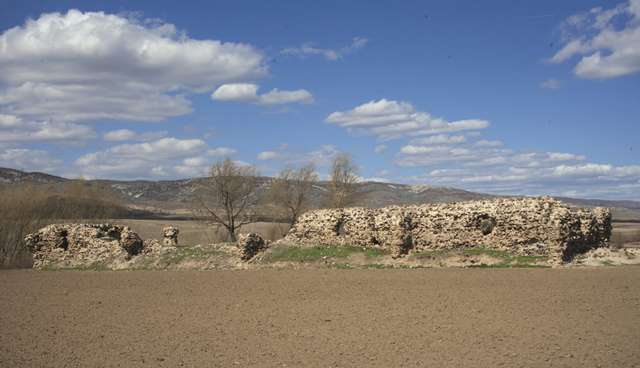
Karpuz Anadolu Selçuklu Eserleri (2008) v.2, p. 479 |
|
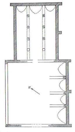
plan drawn by Erdmann |
|
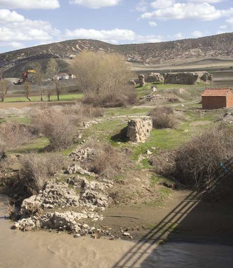
Eravşar, 2017. p. 163; photo I. Dıvarcı |
|
Bilici, vol. 3, p. 489 |
DISTRICT
66 YOZGAT
LOCATION
39.915536, 35.648583
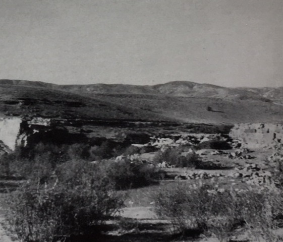
The Çekereksu Han is located about 200 km from Kayseri on the Kayseri-Tokat-Amasya caravan road, which is the current Yozgat-Kadişehri state highway. It is situated in the village of Kesikköprü-Orencik near the Çekerek River. It was built on a sloped field in a northeastern-southwestern orientation, with the southwestern facade facing the hill. A bridge lies about 30-35 m north of the han and probably had one arch, as indicated by the remains of the piers, built with finely-cut masonry stones. No traces of the old caravan road lying beneath the modern road have been discovered, except for a small section between the bridge and the han.
NAMES
This han has been traditionally named after the Çekerek River which flows nearby.
DATE
1239 (supposedly dated by an
inscription, now lost)
PATRON
Like many other hans of the region, the construction of the Çekereksu Han is associated with Mahperi Hunat Hatun. Erdmann speaks of two inscriptions which he assumed were related to these hans. These inscriptions were formerly located in the Çöteli village and in the Kamberli Mosque near Karamağara, but they have, alas, gone missing today. Erdmann, who did not provide the text of these inscriptions, argued that the construction date of this han was ordered by Mahperi Hatun in 1239 in reference to these inscriptions and other structures.
BUILDING TYPE
Covered section with an open courtyard (COC)
Covered section is smaller than the courtyard
Covered section with 3 naves (a middle nave and 2 lateral aisles) perpendicular
to the rear wall
4 lines of support vaults parallel to the rear wall
DESCRIPTION
The entrance to the han is from the southwest. It has the characteristic Seljuk
han plan, comprising a covered section for lodging and a courtyard
with service facilities.
Courtyard: The open courtyard section, which housed the spaces for the various service functions, was located in the same axis as the covered section. The courtyard walls extend past the sides of the northwestern and southeastern walls of the covered section.
No traces of a mosque or any decoration has been uncovered.
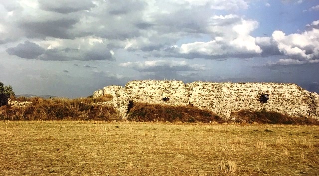
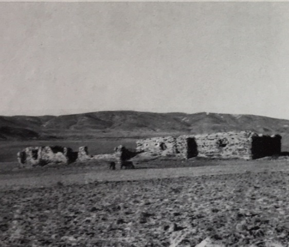
Covered section: The covered section has been largely destroyed, but it is possible to determine the plan from the remaining ruins. It is divided into three naves by two support walls, each placed on four square piers linked by pointed arches. The masonry of the pointed arches extends to the rear wall in the northeast-southwest direction. The central nave is higher and wider than the lateral ones. The structure most probably had a set of stairs leading to the upper floor, although this cannot be determined with certainty. The northwestern wall of the han has been destroyed to a large extent. The intact southwestern wall indicated the height of the original structure. The covered section measured 19 x 25m and the courtyard 27 x 27.5m.
BUILDING MATERIALS
The exterior stone walls, partially in ruins today, are filled with rubble and mortar.
STATE OF CONSERVATION, CURRENT USE
The han has suffered much damage since it was recorded by Erdmann, who drew
its plan. This once important han, in a derelict condition today and left to an
uncertain fate, merits consideration and an urgent restoration to preserve its
architectural heritage and to honor its notable female patron.
BIBLIOGRAPHIC REFERENCES
Acun, H. Bozok Sancaği (Yozat Ili)'nda Türk Mimarası. Ankara: Turk Tarih Kurumu Yayinlari, 2005.
Bilici, Z. Kenan. Anadolu Selçuklu Çaği Mirası. Mimarı = Heritage of Anatolian Seljuk Era. Architecture. 3 vols. Ankara: Türkiye Cumhuriyeti Cumhurbaşkanlığı: Selçuklu Belediyesi, 2016, vol. 3, p. 488-489.
Eravşar, Osman. Yollarin Taniklari (Witnesses of the Way), 2017, pp. 160-163.
Erdmann, Kurt. Das Anatolische Karavansaray des 13. Jahrhunderts, 1976, 1961, p. 57.
Görür, Muhammet. “Anadolu Selçuklu Dönemi Kervansaraylari Kataloğu.” Acun, H. Anadolu Selçuklu Dönemi Kervansaraylari. Ankara: Kültür ve Turizm Bakanliği, 2007, pp. 487.
Karpuz, Haşim. & Kuş, A. & Dıvarcı, I. & Şimşek, F. Anadolu Selçuklu Eserleri, 2008, v.2, p. 479.
Kiepert, R. Karte von Kleinasien, in 24 Blatt bearbeitet, 1902-1916.
Özergin, M. Kemal. "Anadolu'da Selcuklu Kervansaraylari", Tarih Dergisi, XV/20, 1965, p. 147, n. 20.
|
Photo by Erdmann (#66) |
Photo by Erdmann (#65( |
©2001-2026, Katharine Branning; All Rights Reserved.