The Seljuk Han of Anatolia
DURAGAN HAN
One of the rare hans with an off-axis entry to the covered section, the Durağan Han formerly had a bath and a mosque connected with it, and has unusual pointed arches in the courtyard and brick courses in the exterior walls.
|
Karpuz, Anadolu Selçuklu Eserleri (2008) v.2, p. 302 |
|
Eravşar, 2017. p. 351; photo I. Dıvarcı |
 Eravşar, 2017. p. 350; photo I. Dıvarcı |
 Eravşar, 2017. p. 352; photo I. Dıvarcı |
 plan drawn by Erdmann |
 Eravşar, 2017. p. 348; photo I. Dıvarcı |
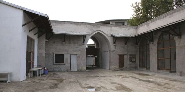 Eravşar, 2017. p. 348; photo I. Dıvarcı |
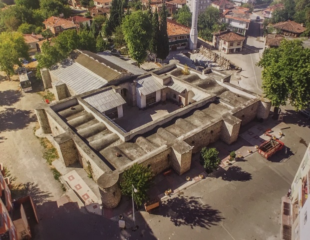 Bilici, vol. 3, p. 257 |
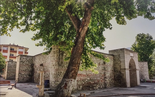 Bilici, vol. 3, p. 259 |
DISTRICT
57 SINOP
LOCATION
41.414313, 35.056043
The Durağan Han is located on the Kastamonu-Samsun-Amasya road, 55 km south of Sinop and 30 km east of Boyabat on the Vezirköprü Road, at the spot where the Gök Irmak and the Kızılirmak Rivers meet in the village of Durağan. It is located in the northeastern part of town.
The modern road passes to the north of the building opposite the entrance of the han. The old caravan road, which used to pass in front of the han, now serves as a connector road to the modern road which passes through the Kizilirmak River valley. The former caravan route, used for centuries, crossed a valley to the east which is now flooded by dam waters. The road continues on to Amasya after passing through the Vezirköprü River basin. A branch of the road heading to the west goes to Kastamonu via Boyabat.
Sinop became the center of political and commercial activities once it was conquered by the Seljuks in 1214 and became the gateway to the Black Sea for the Seljuks. Sinop was ruled successively by the Seljuk, Pervaneids (c. 1296-1322) and Candarid (c. 1322) Beyliks. During this period, the Seljuks were in constant competition with nearby Christian Trebizon (Trabzon) for control of the city, despite that both became Mongol vassals from the mid 13th century onwards. Muslim-Christian relations played an important part in trade. Sinop was the gateway of Anatolia to the northern shores of the Black Sea and vice-versa. Although there is a clear caravan road south from Samsun via the Çakalli Han, Ezinepazar Han, Hatun Han, Tahtoba Han and the Çiftlik Han to Sivas, or dividing south of Amasya to head south-west to Kayseri via the Çekereksu Han, Çinçinli Han and the Sultan Han, there is only one road which was located to bring traffic from Sinop to the main road south from Samsun. There is only one han near Sinop, the Durağan Han, although others may have existed but have now been lost. The road departing from Sinop arrived at the Durağan Han, at which point it bifurcated and led east to Amasya through Vezirköprü and Merzifon.
The leaders of the Candarid Beylik were in contact with the Mamluk rulers of Egypt, and the area became a vibrant trade hub for the export of horses. This trade road was also a departure point for those wishing to travel to the Crimea, Bulgaria and Russia. Ibn Battuta may have stayed in the Durağan Han when he traveled to Sinop c. 1330 on his way to the Crimea.
NAMES
Durak Han
Boyabat-Vezirköprü Han
Pervane Süleyman Han
The han is mentioned in the journals of several Western travelers, notably Division, Cuinet, and Van Lennep.
DATE
1266
REIGN OF
Giyaseddin Keyhüsrev III (dated by inscription)
INSCRIPTION
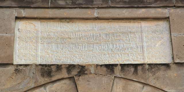
The inscription plaque of the han was seen by various travelers to the region,
notably by Hamilton, in the middle of 19th century. It was subsequently removed
and placed on the wall of the exterior narthex (son cemaat yeri) of the
Ismail Bey Mosque. This mosque, located southwest of the han, was built at the
end of the 19th century. During the renovation project of the han undertaken in
1992, the inscription was returned to its place over the crown door of the
courtyard.
The inscription is quite complete and indicates the name of the sultan, patron and architect. It states that this han was built in 664 (September/October 1266) by the Vizier "Parwana The Great" Suleiman, son of ALi, during the reign of Sultan Giyaseddin Keyhusrev III. The last line of the inscription also states that architect Gevherbaş bin Abdullah "supervised the construction from the beginning to the end." This architect worked with the architect Said El Kayseri, who was the architect of the Kastamonu Yilanlı Hospital, dated 1272, which was commissioned by Ali, son of the great Seljuk Vizier Pervane Muineddin Suleiman, and a mosque built in the Eğlence village of Boyabat by the same patron (its original inscription was reused on a new mosque built in 1945 when the original mosque collapsed.)
The inscription, 150 x 150 cm, is written in Seljuk-style naskh calligraphy, and reads as follows:
The caravanserai is built by the sacred will of the Sultan
Strong and magnificent leader of the faith and father of conquests Keyhüsrev
Sultan of Sultans, powerful ruler, succor of Islam and all Muslims
By the humble and lowly servant of the Great Pervane Süleyman bin Ali, may Allah praise his power, Güherbaş bin Abdullah, in the year 664, in the month of Zilhicce.
PATRON
According to the inscription, the han was built by the Vizier Muin al-Din Suleyman bin Ali, known as the Pervane, during the reign of the Anatolian Seljuk Sultan Giyaseddin Keyhüsrev III in the year 1266 (Hijri 664). At this time, Pervane was the virtual ruler of this part of the Sultanate of Rum (see "History" section). He was also responsible for building medreses in Sinop, Merzifon, Tokat and Kayseri. Only the Sinop and Tokat medreses remain today.
BUILDING TYPE
Covered section and an open courtyard (COC)
Covered section smaller than the courtyard
Covered section with 3 naves (a central aisle and 1 aisle on each side running perpendicular to
the back wall
5 lines of support cross vaults parallel to the rear wall
DESCRIPTION
The Durağan Han
displays the typical design layout of Seljuk hans, comprising a covered section
used for lodging with a courtyard for service areas located in front of it, but
with a twist to the orientation.
Courtyard:
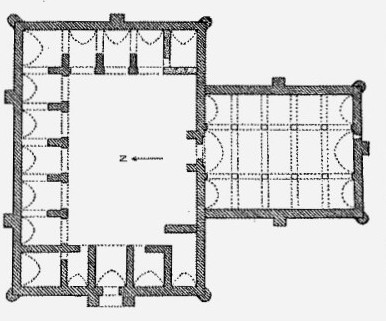
The courtyard is wider than the covered section and is placed perpendicularly to it, which is not the typical layout of a Seljuk Han. The entrance door to the courtyard and the entrance door to the covered section are not on axis, as is generally the case for the typical open courtyard and covered section plan hans. However, this atypical orientation is also seen in the Kesikköprü, Zazadin and Ağzikara Hans. This orientation of the courtyard (east) and the covered section (south) was not apparently done due to the site requirements. There are several waterspouts on the facade.
The western side of the courtyard comprises two sections, and they are significantly different. The southern section is 5.35 m high while the northern section is 5.07 m high.
The mosque for the han was believed to have been located in a room in the doorway passage to the right of the courtyard.
Covered section:
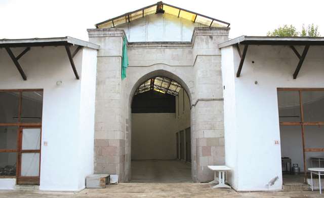
The entrance door to the covered section is located in the middle of the southern wall. The façade of this side is laid with finely-cut horizontal bricks, laid in five courses between a bed of mortar. Reuse spolia stones were also used.
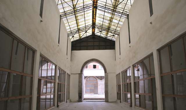
The covered section comprises three naves covered by pointed vaults placed perpendicularly to the wall opposite the entrance. The middle nave is higher and wider than the lateral naves. Vaults are positioned over two support walls, and each of these support walls comprised four square stone piers. No trace of these piers remains today, as they have been replaced by the facades of the shops currently installed in the han. The covered section is currently a modern structure of reinforced concrete piers and walls.
There is a window opposite the entrance, but there were most certainly other slit windows for the space.
The entrance door to the han is located in the middle of the southern wall and was completely rebuilt during the last renovation project. The walls are made of pitch-faced stone and brick. The facade of the southern wall is laid with finely-cut bricks, laid in five courses between a bed of filler. These brick courses add a distinctive feature to the han.
Two round support towers are located at the corners of the southern exterior wall, and a square tower is set in the middle of the eastern and western walls. It is not possible to determine the original construction techniques used in the covered section, now covered by a metal roof, as it was completely demolished before the renovation. The springing of the vaults and the belt courses can still be distinguished, which suggests that the covered section was originally covered by a pointed barrel vault in each of the three naves, running parallel to each other in a north-south orientation.
DECORATION
There is no decoration in the han, other than the brickwork courses on the exterior wall. The brick courses, which add a distinctive feature to the han, are laid at the same level in the exterior side walls.
The courtyard arches have pointed arches in the Persian style, an atypical Anatolian shape. It is possible that Pervane may have commissioned a Persian architect to build this han like he did for his mosque at Sinop (built in 1256).
DIMENSIONS
Total external area: 1435 m2. The han is
quite large.
Area of covered section: 330m2
Area of courtyard: 925m2
STATE OF CONSERVATION, CURRENT
USE
This han was in used until the 1920s, at which time transportation patterns
changed (trucks began to replace horse carts) and it was no longer necessary to
stopover here. Parts of the han were demolished at this time, and the photos
taken by Erdmann in 1951 and 1954 show that the han was deserted.
The han was registered in 1982 as property of the Municipality of the city of Durağan, who retains all rights to its use. The han now serves as a municipal garage and storage area.
Restoration of this han began in 1992 and was completed in 2007. The entrance portal to the covered section and most of the covered section were entirely rebuilt at this time. The original structure was substantially altered during the renovation project and has lost many of its original features. The covered section is now covered by a metal roof.
A bath was formerly located to the north of the han, but was demolished in 1992 and is now being used as a public park. The mosque located near the han is believed to have been once connected with it, and has been completely restored using its original materials.
In 2014, the Samsun Regional Directorate of Foundations voted to invest in the building in order to reverse the faults of the 1992 renovation project.
BIBLIOGRAPHIC REFERENCES
Altun, Ara. An Outline of Turkish Architecture in the Middle Ages, 1990, p. 200.
Bilici, Z. Kenan. Anadolu Selçuklu Çaği Mirası. Mimarı = Heritage of Anatolian Seljuk Era. Architecture. 3 vols. Ankara: Türkiye Cumhuriyeti Cumhurbaşkanlığı: Selçuklu Belediyesi, 2016, vol. 3, pp. 257-259.
Cuinet, V. La Turquie d'Asie, v. I, 1894.
Division, G.B. A Handbook of Asia Minor. London, 1919.
Eravşar, O. & Yavuz, A.T. Ortacağda Küzey Anadolu Yollari ve Yol Üstü Kurluşlari. 109K369 Tubitak Projesi Sonuç Raporu, ULAKBIM, 2010.
Eravşar, Osman. Yollarin Taniklari (Witnesses of the Way), 2017, p. 346-352.
Erdmann, Kurt. Das Anatolische Karavansaray des 13. Jahrhunderts, 1961, pp. 72-74, no. 20 (plan, photos).
Görür, Muhammet. Anadolu Selçuklu Dönemi Kervansaraylari Kataloğu. Acun, H. Anadolu Selçuklu Dönemi Kervansaraylari. Ankara: Kültür ve Turizm Bakanliği, 2007, pp. 492.
Karpuz, Haşim. & Kuş, A. & Dıvarcı, I. & Şimşek, F. Anadolu Selçuklu Eserleri, 2008, vol. 2, p. 302.
Kiepert, R. Karte von Kleinasien, in 24 Blatt bearbeitet, 1902-1916.
Özergin, M. Kemal. Anadoluda Selçuklu Kervansarayları, Tarih Dergisi, XV/20, 1965, p. 159, n. 98.
Peacock, A.C.S. Sinop: A Frontier City in Seljuq and Mongol Anatolia. Ancient Civilizations from Scythia to Siberia. 16, 2010, pp. 103-124.
Rice, Tamara Talbot. The Seljuks in Asia Minor, 1961, p. 206.
Van Lennep, H. J. Travels in Little-known Parts of Asia Minor. With Illustrations of Biblical Literature and Researches in Archaeology: Vol. 1. London, 1870, chapter III, p. 61, map 1.
|
Eravşar, 2017. p. 349; photo I. Dıvarcı
|
Portal leading to the covered section
|
|
photos below before the completion of the restoration project in 2007 |
|
|
|
|
|
Inscription plaque (kitabesi) over main portal |
Cells in main courtyard |
|
Photo by Erdmann (#100) |
Photo by Erdmann (#98) |
|
Photo by Erdmann (#99)
|
|
©2001-2025, Katharine Branning; All Rights Reserved.