![]()
The Seljuk Han of Anatolia
KURU HAN 1 & 2
Located on the busy Kayseri-Aleppo trade route, this single-nave han has a secondary outbuilding to the rear, perhaps used as a mountain pass guard station.
|
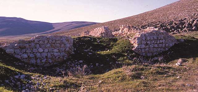
Eravşar, 2017. p. 77; photo I. Dıvarcı |
|
|
|
|
|
|
|
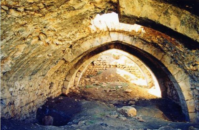
Bilici, vol. 2, p. 106 |
DISTRICT
46 KAHRAMANMARAS
LOCATION
38.434885, 36.852347
The Kuru Han 1 is located 40 km northwest of Elbistan, and 12 km from the village of Altinelma (Norşun), along the old Kayseri-Malatya-Aleppo trade route. It is located in the valley between Mount Hüseyinağa to the north of Elbistan and Mount Oğlakkaya to the west. It is located between Tanir and Marabuz (or the Hurman Castle) on the Göksun-Elbistan Road, 30 km north of Afşin.
The dirt road from the Hurman Castle to Altinelma passes approximately 10 meters from the han and another road leads to the village of Tanir. This important route was used by caravans to cross the Middle Taurus mountain range from south to north in order to reach central Anatolia, and has been in use since ancient times, as can be seen by the remains of Roman period milestones along it.
Kahramanmaraş was a significant town of the Anatolian Seljuks, due to its geographical position and location at a very strategic point of Anatolia. Researchers believe that there were many architectural works built by the Seljuks here, but all have been destroyed. However, there are several hans which remain, including this one, the Coğul, Kurttepe, Sevdilli, Nurhak, Çevirme, Kamereddin and Hanobaşi hans. This han is not far from the important han at the holy site of Eshab-i Keyf.
The Kayseri-Elbistan-Aleppo Route was an important route in the Seljuk era. From the Sivas and Kayseri connection, routes led south to the Mesopotamian region through Malatya and Elbistan, which was the road taken by the Mamluk Baybars when he invaded Anatolia in 1256. The first destination after exiting Kayseri was the Ispile Han, of which only a few ruined sections remain. The next station was the Karatay Han. The road generally followed the river beds and passed through rugged terrain before arriving at the Yabanlu Bazaar, the trade fair market forum since the days of the Assyrian trade colonies Period. The road continued on, passing by the Kuru Han 2, the Çoğul and the Afşin Hans. The next station was the Kuru Han. The road continued towards the Hurman Castle from here. The next station on the road heading towards Elbistan was the Kuru Han 2. There was also a mountain pass (derbent) located near this han. The road arrived at the Çoğul Han, and bifurcated after the Çavli Han. One branch led to Elbistan and the other to Afşin. Elbistan was a frontier town which served as a gateway to the region. Because of its key location, the Seljuks had taken certain precautions to both protect the city and to control access to it. One of these measures was the construction of a mountain pass (derbent) in the settlement formerly known as Akça Derbent. The next station was the Zilli Han. The road then split towards the east, connected to Malatya through Nurhak and then the road split again towards the south to arrive at Aleppo via Gaziantep.
The Seljuk sultanate conquered this district from the Danishmendid Prince Yağibasan in the mid-12th century. Over the next century, much building was accomplished. Part of the district’s importance came from the fact that it was an important thoroughfare from Kayseri to Besni in the Euphrates district south of the Taurus. The road passed through the Hurman valley and over the plain to Elbistan. It then left the plain by the southeastern route through the Nurhak mountains. Two hans were built on this route over the plain, of which only this Kuru Han survives in part. The other han, called the Cavlihan, was destroyed in the 80s, and its position on a direct line between Tanir and Elbistan shows the alignment of this route.
NAMES
Cavli Han
The locals call this han the Kuru (“Dry”) Han, without any reason for this appellation.
INSCRIPTION
There is no inscription plaque.
DATE
mid 13th c.
The han was constructed before 1277, as it was probably built simultaneously with the other hans along this route.
The han is mentioned in a census document from 1563 as a han linked to the town of Norşun, and which stated that it brought in 1000 akçe of earnings.
PATRON
According to historic sources, the benefactor of the han is the Seljuk emir Nizameddin Çavli, who also founded other charitable establishments in the Afşin-Elbistan region. Çavli served during the time of Sultan Izzeddin Keykavüz II (r. 1246-57). Qadi Muhyiddin Ibnü Abduzzahir, the clerk of Baybars who documented his military expedition to Anatolia, mentions the Çavli Han in Afşin which was built by Nizameddin Çavli, so the han had to have been built before 1277.
DESCRIPTION
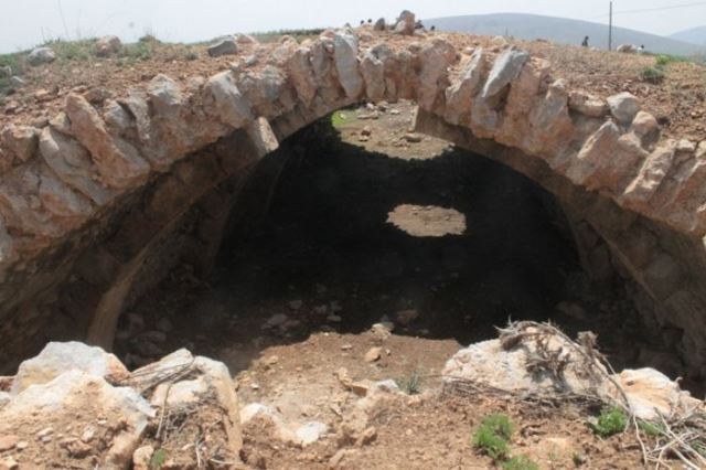
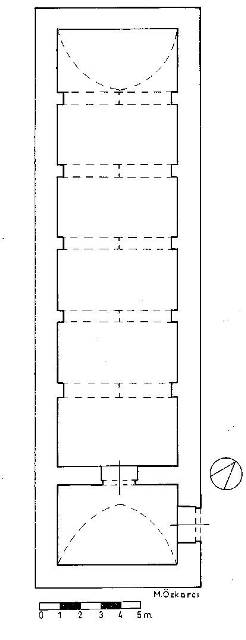
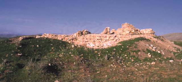
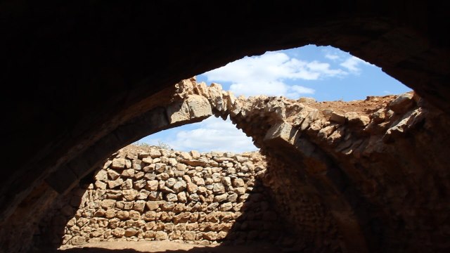
The han is oriented north-south. It has the covered section only plan and measures 215m2. The inner dimensions are 21.54m x 5.78m. The han comprises a covered section with one nave, covered by a pointed barrel vault.
The han is buried up to the top of the exterior vault and the interior impost blocks. Five cut stone arches are equally spaced inside the vault. Scavengers have removed many of the blocks in the north wall and in the floor sections. By looking through the holes left by the stone pilferers, it has been determined that the inner surfaces were plastered with lime mortar. Two horizontal water pipes, some 1.50 meters above the ground level, have been found northeast of the han which may indicate that there were other structures surrounding the han.
This is a simple han, with no decoration.
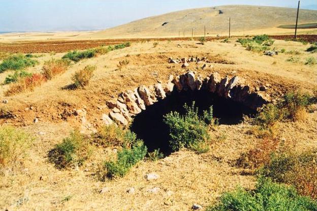
EXTERIOR
Ruins of another han are located to the southwest of the han, in a similar to the situation as seen at the Kizilören Han. This second han, called Kuru Han 2, could have served as a mountain pass station.
BUILDING MATERIALS
The building’s walls, built of pitch-faced stones filled with mortar and rubble, are thin.
DIMENSIONS
5.90 X 21.60m
STATE OF CONSERVATION, CURRENT USE
After this road fell out of use, the han was left deserted and fell into ruins. The northern section of the barrel vault is in sound condition, but the rest is in ruins.
BIBLIOGRAPHIC REFERENCES
Bilici, Z. Kenan. Anadolu Selçuklu Çaği Mirası. Mimarı = Heritage of Anatolian Seljuk Era. Architecture. 3 vols. Ankara: Türkiye Cumhuriyeti Cumhurbaşkanlığı: Selçuklu Belediyesi, 2016, vol. 2, p. 106.
Eravşar, O. & Yavuz, A.T. “Kayseri- Elbistan Kervanyolu”. Konya Kitabi X, 2007.
Eravşar O. , Anatolia- Syria Caravan Road and Menzil Caravansaries in the 13th Century, 2007.
Eravşar, Osman. Yollarin Taniklari (Witnesses of the Way), 2017, pp. 76-78.
Erdmann, Kurt. Das Anatolische Karavansaray des 13. Jahrhunderts, 1961. Vol. 1, pp. 163-4 no. 49.
Görür, Muhammet. “Anadolu Selçuklu Dönemi Kervansaraylari Kataloğu.” Acun, H. Anadolu Selçuklu Dönemi Kervansaraylari. Ankara: Kültür ve Turizm Bakanliği, 2007, p. 512.
İbni Bibi, 1996, p. C1, 135.
Hillenbrand, R. Islamic Architecture: Form, function and meaning, 1994, p. 553 fig 6.60.
Kiepert, R. Karte von Kleinasien, in 24 Blatt bearbeitet, 1902-1916.
Özergin, M. Kemal. “Anadolu’da Selçuklu Kervansarayları”, Tarih Dergisi, XV/20, 1965, p. 156, p. 78.
Özkarcı, Mehmet. “Kahramanmaraş’ta Selçuklu Mimarisine Bakiş,” Uluslararasi Selçuklu Döneminde Maraş Sempozunu, 17-19 November, 2016, pp. 14-53.
Sinclair, T.A. Eastern Turkey: An Architectural and Archeological Survey, volume III. London, 1989, p. 479.
|
Eravşar, 2017. p. 76; photo I. Dıvarcı |
|
 |
 |
©2001-2026, Katharine Branning; All Rights Reserved.